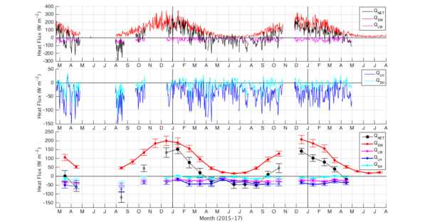
Data from: Episodic Southern Ocean heat loss and its mixed layer impacts revealed by the furthest south multi-year surface flux mooring
Data from: Episodic Southern Ocean heat loss and its mixed layer impacts revealed by the furthest south multi-year surface flux mooring
About this collection
- Extent
-
1 digital object.
- Cite This Work
-
Ogle, Sarah E.; Tamsitt, Veronica; Josey, Simon A.; Gille, Sarah T.; Cerovečki, Ivana; Talley, Lynne D.; Weller, Robert A. (2018). Data from: Episodic Southern Ocean heat loss and its mixed layer impacts revealed by the furthest south multi-year surface flux mooring. UC San Diego Library Digital Collections. https://doi.org/10.6075/J0T43R83
- Description
-
This dataset contains Quality Controlled daily mean air-sea heat flux estimates from the NSF Ocean Observatories Initiative (OOI) Southern Ocean mooring site for the period February 2015 to August 2017, as used in the analysis of Ogle et al. 2018 (doi:10.1029/2017GL076909). Initial data processing and estimates of heat flux terms using a modified version of the COARE 3.5 flux algorithm from Edson et al. [2013] (documented at https://github.com/ooici) was completed by the OOI Data Team and can be obtained from the NSF OOI Data Portal https://ooinet.oceanobservatories.org/. Secondary data quality control and temporal averaging was undertaken by Sarah Ogle and Veronica Tamsitt at Scripps Institution of Oceanography.
All of the variables apart from shortwave radiation have undergone the OOI QC process (http://oceanobservatories.org/quality-control/), which may include all or some of the following: global range test, spike test, and stuck value test. The upper limit of the OOI QC global range test applied to the shortwave radiation was too low, and thus we do not apply this test to the shortwave radiation data. We applied our own quality control to all of the data including removing negative SWR values, extreme spikes, repeating values, and zero wind speed values. - Scope And Content
-
Format:
The data are provided as both Matlab structure array (.mat) and NetCDF formats.
Parameters:
Each file contains our quality controlled data derived directly from OOI Data Products (variables described at http://oceanobservatories.org/data-products/). The NetCDF format files include metadata associated with each parameter including the OOI description, units, fill value, and data_product_identifier typically, which includes a common name for the product (e.g. density) as well as its processing level (e.g. L0, L1, L2) .
Resolution:
The data are available as either hourly averages or daily averages, where the daily average is only calculated on days with no missing hourly averages. - Creation Date
- 2015 to 2017
- Date Issued
- 2018
- Authors
- Analysts
- Contributors
- Funding
-
Please refer to the OOI Data Usage Policy http://oceanobservatories.org/usage-policy/.
S.E.O., L.D.T., S.T.G, and V.T. were supported by the Southern Ocean Carbon
and Climate Observations and Modeling Project under NSF PLR-1425989; V.T. and I.C.
received significant support from NSF OCE-1357072. S.T.G. and I.C. were also supported
by NSF OCE-1658001. S.A.J is supported by the UK Natural Environment Research
Council, including the ORCHESTRA grant (number NE/N018095/1). - Geographic
- Topics
Formats
View formats within this collection
- Related Resources
- Ogle, S. E., V. Tamsitt, S. A. Josey, S. T. Gille, I. Cerovecki, L. D. Talley, and R. A. Weller. (2018), Episodic Southern Ocean heat loss and its mixed layer impacts revealed by the furthest south multi-year surface flux mooring, Geophys. Res. Lett. https://doi.org/10.1029/2017GL076909
- NSF Ocean Observatories Initiative Data Portal, Bulk Meteorology Instrument Package (GS01SUMO-SBD11-06-METBKA000) data from 2015/02/18 to 2017/08/01. Downloaded on 2017/08/03. https://ooinet.oceanobservatories.org
- NSF Ocean Observatories Initiative Data Portal, Bulk Meteorology Instrument Package (GS01SUMO-SBD12-06-METBKA000) data from 2015/02/18 to 2017/08/01. Downloaded on 2017/08/03. https://ooinet.oceanobservatories.org
- Ocean Observatories Initiative CI repositories at GitHub: https://github.com/ooici
- Edson, J. B., et al. 2013. On the exchange of momentum over the open ocean. J. Phys. Oceanogr., 43, 1589–1610. https://doi.org/10.1175/JPO-D-12-0173.1
Primary associated publication
Source data
Software
Reference
Other resource
 Library Digital Collections
