Western Pacific Atmospheric River Object Data from MODE detection software using West-WRF, GEFS, and MERRA-2
Western Pacific Atmospheric River Object Data from MODE detection software using West-WRF, GEFS, and MERRA-2
About this collection
- Extent
-
1 digital object.
- Cite This Work
-
DeHaan, Laurel L.; Martin, Andrew C.; Weihs, Rachel R.; Delle Monache, Luca; Ralph, F. Martin (2021). Western Pacific Atmospheric River Object Data from MODE detection software using West-WRF, GEFS, and MERRA-2. UC San Diego Library Digital Collections. https://doi.org/10.6075/J0W37TVB
- Description
-
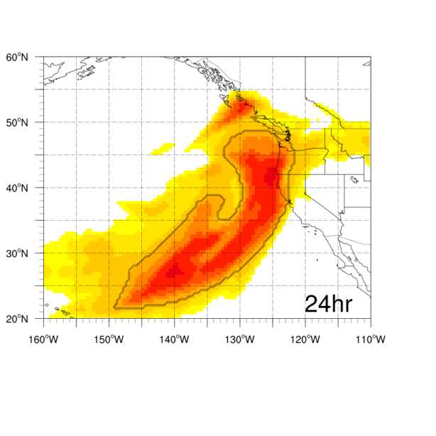
The .tgz files contain NetCDF files of atmospheric river (AR) objects as processed through the Method for Object-based Diagnostic Evaluation (MODE; Bullock et al. 2016) software. MODE is part of the Model Evaluation Tools (MET; https://dtcenter.org/community-code/model-evaluation-tools-met) package provided by the National Center for Atmospheric Research (NCAR). ARs are narrow areas of intense moisture transport that can be identified using gridded fields of integrated vapor transport (IVT) from a numerical weather prediction model and/or analysis (described below). Objects are used to evaluate the forecast skill of the AR over an 11 year (2006-2017) period during the cool season (Dec-Mar).
AR objects are defined based on an IVT threshold (250, 500, 750, 1000 kg m-1 s-1), length, and location providing a well-defined AR region with a geographical footprint for both a forecast and an analysis. Fixed thresholds are used to determine the boundary of the AR object applied to evaluate different strengths of AR intensity. Length restrictions for the AR objects are based on IVT threshold: At 250 kg m-1s-1 the minimum required length to detect an AR is 2000 km, at 500 kg m-1s-1 it is 1500 km, at 750 kg m-1s-1 it is 1000 km, and at 1000 kg m-1s-1 it is 550 km. At all thresholds, the centroid of the object is required to be north of 24o latitude (to exclude tropical areas of high IVT) and east of 205o (to exclude ARs near the western boundary of our domain). MODE uses convolution thresholding as described in Bullock et al. (2016), which has two tunable parameters: threshold (as discussed above) and convolution radius. This is done independently for a forecast and for a verification (analysis).
After AR objects have been identified for both the forecast and analysis, MODE determines if the forecasted AR matches the analysis AR (is a “hit”) using fuzzy logic, with tunable weights for different attributes. We have given the distance between the boundaries of the two objects the strongest weight in determining a match between a forecast and analysis. The distance between the centroids of the objects and the size of the objects are the next most important factors, each with half the weight of the boundary distance. Other object attributes have smaller weights. If the forecasted AR meets the criteria for matching the analysis AR, then statistics are computed comparing the two objects.
This analysis evaluated two numerical weather prediction datasets (coarse and fine scale) against ground truth. The coarser model IVT was calculated from the control member from the Global Ensemble Forecast System (GEFS) reforecast (Zhou et al. 2017). The IVT is calculated from the half degree resolution using 33 pressure levels from 1000 hPa to 200 hPa. The fine scale IVT was calculated from a dynamically downscaled GEFS forecast using the regional Weather Research and Forecasting (WRF) model (Skamarock et al., 2008). This model is run at a 9 km resolution over the Eastern Pacific and extreme U.S. West Coast. The configuration of the WRF model is primarily based upon Martin et. al 2018, with the exceptions of a larger domain (see domain extent) and increased vertical levels (60). - Creation Date
- 2006-12 to 2017-03
- Date Issued
- 2021
- Author
- Principal Investigator
- Researchers
- Contributor
- Funding
-
Atmospheric River Program Phase 2-202203. Award #4600013361
- Topics
-
- Atmospheric river
- Atmospheric river detection
- Forecast skill
- Global Ensemble Forecast System (GEFS)
- Integrated vapor transport (IVT)
- Method for Object-based Diagnostic Evaluation (MODE)
- Modern-Era Retrospective analysis for Research and Applications, Version 2 (MERRA-2)
- Numerical weather prediction
- Weather Research and Forecasting (WRF)
Formats
View formats within this collection
- Language
- English
- Related Resources
- DeHaan, L. L., Martin, A. C., Weihs, R. R., Delle Monache, L., & Ralph, F. M. (2021). Object-based Verification of Atmospheric River Predictions in the Northeast Pacific, Weather and Forecasting. https://doi.org/10.1175/WAF-D-20-0236.1
- Global Ensemble Forecast System (GEFS): https://www.ncei.noaa.gov/products/weather-climate-models/global-ensemble-forecast
- Weather Research & Forecasting Model (WRF): https://www.mmm.ucar.edu/weather-research-and-forecasting-model
- West Weather Research and Forecasting (West-WRF) Model Forecasts: https://cw3e.ucsd.edu/west-wrf/
- Bullock, R. G., Brown, B. G., & Fowler, T. L. (2016). Method for Object-Based Diagnostic Evaluation (No. NCAR/TN-532+STR). https://doi.org/10.5065/D61V5CBS
- Martin, A., F.M. Ralph, R. Demirdjian, L. DeHaan, R. Weihs, J. Helly, D. Reynolds, and S. Iacobellis, 2018: Evaluation of Atmospheric River Predictions by the WRF Model Using Aircraft and Regional Mesonet Observations of Orographic Precipitation and Its Forcing. J. Hydrometeor., 19, 1097–1113. https://doi.org/10.1175/JHM-D-17-0098.1
- Skamarock, W. C., Klemp, J. B., Dudhia, J., Gill, D. O., Barker, D., Duda, M. G.,Xiang Yu, H., Wang, W., and Powers, J. G., 2008: A description of the Advanced Research WRF version 3. NCAR Tech. Note NCAR/TN-475+STR, 113 pp. https://doi.org/10.5065/D68S4MVH
- Zhou, X., Y. Zhu, D. Hou, Y. Luo, J. Peng, and R. Wobus, 2017: Performance of the New NCEP Global Ensemble Forecast System in a Parallel Experiment. Wea. Forecasting, 32, 1989–2004. https://doi.org/10.1175/WAF-D-17-0023.1
Primary associated publication
Software
Reference
 Library Digital Collections
