Data from: Enhanced surf zone and wave runup observations with hovering drone-mounted LiDAR
Data from: Enhanced surf zone and wave runup observations with hovering drone-mounted LiDAR
About this collection
- Extent
-
1 digital object.
- Cite This Work
-
Fiedler, Julia W.; Kim, Lauren; Grenzeback, Robert L.; Young, Adam P.; Merrifield, Mark A. (2021). Data from: Enhanced surf zone and wave runup observations with hovering drone-mounted LiDAR. UC San Diego Library Digital Collections. https://doi.org/10.6075/J04F1P9V
- Description
-
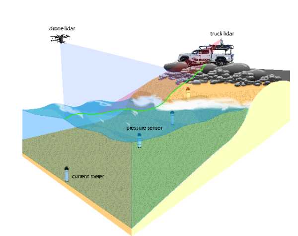
The Drone LiDAR data contained in this object were obtained during the Storm CoAstal Response Project (SCaRP) field experiment of Winter 2019-2020. The study was conducted at Torrey Pines State Beach in San Diego, California, USA. The gently-sloped mixed cobble and sand beach was instrumented with a transect of buried pressure sensors extending from the cobble-covered upper beach to ~110 m offshore. A drone-mounted LiDAR hovered at 20 m above the water roughly 40 m offshore, and a truck-mounted terrestrial LiDAR (elevation 6.3 m, NAVD88) parked on an elevated road above the back beach. Data were collected during high tide (~MHHW, 1.57 m NAVD88) from 1800-1924 UTC 14 December 2020 and 1700-1920 UTC 24 February 2020.
The dataset includes LiDAR derived 'time-stacks' from both LiDAR instruments; wave runup statistics, spectra, and time series for each time-stack; and pressure sensor surface-corrected time series.
Abstract: We demonstrate that a hovering, drone-mounted laser scanner (LiDAR) paired with a survey-grade satellite and inertial positioning system measures the wave transformation across the surf zone and the resulting runup with accuracy almost equal to a stationary truck-mounted terrestrial LiDAR. The drone, a multi-rotor small unmanned aircraft system (sUAS), provides unobstructed measurements by hovering above the surf zone at 20 m elevation while scanning surfaces along a 150 m-wide cross-shore transect. The drone enables rapid data collection in remote locations where terrestrial scanning may not be possible. Allowing for battery changes, about 17 minutes of scanning data can be acquired every 25 minutes for several hours. Observations were collected with a wide (Hs = 2.2 m) and narrow (Hs = 0.8 m) surf zone, and are validated with traditional land-based survey techniques and an array of buried pressure sensors. Thorough post-processing yields a stable (mean standard deviation = 1.7 cm) back beach topography estimate comparable to the terrestrial LiDAR (mean standard deviation = 0.8 cm). Statistical wave properties and runup values are calculated, as well as bathymetry inversions using a relatively simple nonlinear correction to wave crest phase speed in the surf zone, illustrating the utility of drone-based LiDAR observations for nearshore processes. - Date Collected
- 2019-12-14 to 2020-02-24
- Date Issued
- 2021
- Authors
- Advisor
- Contributor
- Funding
-
The research was supported by the U.S. Army Corps of Engineers (W912HZ192) and California Department of Parks and Recreation (C19E0026).
- Geographics
- Topics
Formats
View formats within this collection
- Language
- No linguistic content; Not applicable
- Identifier
-
Identifier: Adam P. Young: https://orcid.org/0000-0001-7985-9528
Identifier: Julia W. Fiedler: https://orcid.org/0000-0002-4797-8933
Identifier: Lauren Kim: https://orcid.org/0000-0003-2821-1806
Identifier: Mark A. Merrifield: https://orcid.org/0000-0002-5026-8393
- Related Resource
- Fiedler, J. W., Kim, L., Grenzeback, R. L., Young, A. P., & Merrifield, M. A. (2021). Enhanced Surf Zone and Wave Runup Observations with Hovering Drone-Mounted Lidar, Journal of Atmospheric and Oceanic Technology, 38(11), 1967-1978. https://doi.org/10.1175/JTECH-D-21-0027.1
Primary associated publication
 Library Digital Collections
