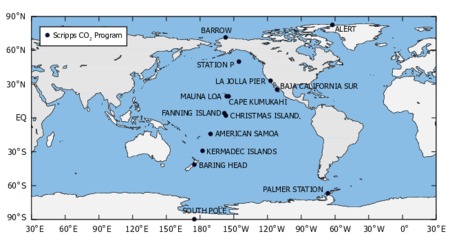
Map of Scripps CO2 Program Sampling Stations
- Collection
- Cite This Work
-
Keeling, Ralph F.; Keeling, Charles D. (2017). Map of Scripps CO2 Program Sampling Stations. In Scripps CO2 Program Data. UC San Diego Library Digital Collections. https://doi.org/10.6075/J09S1PCR
- Description
-
Measurements of atmospheric CO2 concentration in our program began in 1957 at La Jolla, California and at the South Pole, and in 1958 at Mauna Loa Observatory. These measurements were gradually extended during the 1960's and 1970's to comprise sampling at an array of stations from the Arctic to Antarctica.
- Creation Date
- 2017
- Date Issued
- 2017
- Contributor
- Topics
Format
View formats within this collection
- Language
- No linguistic content; Not applicable
- Identifier
- Related Resource
- Sampling Stations at Scripps CO2 Program website: https://scrippsco2.ucsd.edu/data/atmospheric_co2/sampling_stations
Other version
- License
-
Creative Commons Attribution 4.0 International Public License
- Rights Holder
- UC Regents
- Copyright
-
Under copyright (US)
Use: This work is available from the UC San Diego Library. This digital copy of the work is intended to support research, teaching, and private study.
Constraint(s) on Use: This work is protected by the U.S. Copyright Law (Title 17, U.S.C.). Use of this work beyond that allowed by "fair use" or any license applied to this work requires written permission of the copyright holder(s). Responsibility for obtaining permissions and any use and distribution of this work rests exclusively with the user and not the UC San Diego Library. Inquiries can be made to the UC San Diego Library program having custody of the work.
- Digital Object Made Available By
-
Research Data Curation Program, UC San Diego, La Jolla, 92093-0175 (https://lib.ucsd.edu/rdcp)
- Last Modified
2023-06-01
 Library Digital Collections
